Differential Absorption Lidar, UHOH DIAL
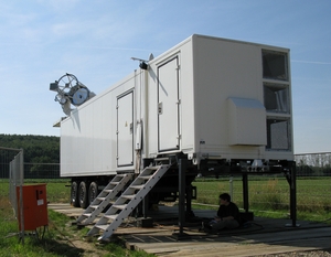
The differential absorption lidar (DIAL) of University of Hohenheim (UHOH) measures high-resolution profiles of atmospheric water vapour number density and particle backscatter ratio at 820 nm both in day and at night (Behrendt et al. 2009, Behrendt et al. 2010). The instrument is housed in a 12-m trailer and can thus be moved to a certain site of interest. By use of an 80-cm scanning telescope, not only vertical profiles but fields of atmospheric humidity can be measured. Different types of scan patterns can be made. The UHOH DIAL provides at date the highest resolution remote sensing data of water vapour worldwide. This is achieved by high laser power (> 4 W average power and a repetition rate of 250 Hz), a large telescope (80 cm diameter of the primary mirror), as well as very efficient receiver optics and detectors (Schiller 2009, Wagner 2009).
DIAL is a technique which measures the water vapour number density with very high resolution in space and time by alternate emission of short laser pulses which are absorbed strongly by water vapour in the atmosphere (online) and which are not absorbed (offline) and by time-resolved detection of the atmospheric backscatter signals. The UHOH DIAL employs laser radiation in the near IR between 815 and 820 nm, a spectral region where several water vapour absorption lines are present and can be selected according to range of interest for optimum measurements and amount of humidity present in the atmosphere. With the water vapour absorption coefficient for the online radiation known from high-accuracy laboratory measurements, the atmospheric backscatter profiles alone provide a profile of the water vapour number density; instrumental parameters cancel out. Consequently, no calibration of the DIAL data needs to be performed.
The UHOH DIAL is operated in scanning mode with typically 0.1 to 5 degree/s scan speed performing different kinds of range-height indicator (RHI) or plane-polar indicator (PPI) scan pattern (for the former the elevation angle is varied while the azimuth angle is kept constant; for the latter vice versa).
The backscatter profiles of the DIAL are stored for each laser pulse, i.e., with 250 Hz, and a range-resolution of 3 m up to 20 km range. Thus maximum freedom is possible in post-processing of the data. The data products of the DIAL are profiles of water vapour number density with typical resolutions of 15 to 150 m with a temporal resolution of 1 to 10 s. But spatial and temporal resolution can be traded off against each other. An accuracy of better 5 % is expected for the above mentioned resolutions. The high accuracy could be verified by intercomparisons of the water vapor data measured with ground-based and airborne remote sensing (Bhawar et al. 2010).
2D water-vapor measurements of the UHOH DIAL system revealing inhomogeneities in the surface and the boundary layer.
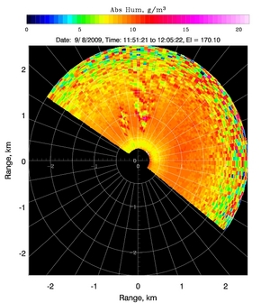 | 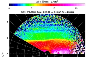 |
| Plane-Polar Indicator Scan | Range-Height Indicator Scan |
| References |
|---|
| Behrendt, A., V. Wulfmeyer, A. Riede, G. Wagner, S. Pal, H. Bauer, M. Radlach, and F. Späth, 2009: 3-Dimensional observations of atmospheric humidity with a scanning differential absorption lidar. In Richard H. Picard, Klaus Schäfer, Adolfo Comeron et al. (Eds.), Remote Sensing of Clouds and the Atmosphere XIV, SPIE Conference Proceeding Vol. 7475, ISBN: 9780819477804, 2009, Art. No. 74750L, DOI:10.1117/12.835143 |
| Behrendt, A., V. Wulfmeyer, A. Riede, G. Wagner, S. Pal, H. Bauer, and F. Späth, 2010:Scanning differential absorption lidar for 3D observations of the atmospheric humidity field. 25th International Laser Radar Conference (ILRC), July 5-9, 2010, St. Petersburg, Russia. |
| Schiller, M., 2009: A high-power laser transmitter for ground-based and airborne water-vapor measurements in the troposphere. Doctoral thesis, University of Hohenheim, Stuttgart, Germany. |
| Wagner, G., 2009: Theoretical analysis and design of high-performance frequency converters for LIDAR systems. Doctoral thesis, University of Hohenheim, Stuttgart, Germany. |
| Bhawar, R., P. Di Girolamo, D. Summa, C. Flamant, D. Althausen, A. Behrendt, C. Kiemle, P. Bosser, M. Cacciani, C. Champollion, T. Di Iorio, R. Engelmann, C. Herold, S. Pal, A. Riede, M. Wirth, and V. Wulfmeyer, 2010: The Water Vapour Intercomparison Effort in the Framework of the Convective and Orographically-Induced Precipitation Study: Airborne-to-Ground-based and airborne-to-airborne Lidar Systems. Submitted for publication in the COPS Special Issue of the Q. J. R. Meteorol. Soc. |